The Nilgiri (blue mountains)

- Range of mountains forming a part of the Western Ghats situated in the western part of Tamil Nadu state at the junction of Karnataka and Kerala states in Southern India.
There are at least 24 peaks above 2,000 metres (6,600 ft) which make the southwestern edge of the Deccan Plateau.
- Doddabetta is the highest peak (2,637 metres or 8,650 feet) in the Nilgiri district of Tamil Nadu state.
Location.
The hills are separated from the Karnataka plateau to the north by the Moyar River and from the Anaimalai Hills and Palni Hills to the south by the Palghat Gap.
Conservation.
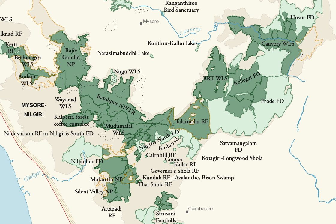
The Nilgiri Biosphere Reserve, which includes the Nilgiri Hills, forms a part of the protected bio reserves in India and is a part of UNESCO World Network of Biosphere Reserves.
Waterfall.
-The highest waterfall, Kolakambai Fall, north of Kolakambai hill, has an unbroken fall of 400 feet (120 m).
- Udhagamandalam (sometimes Ootacamund), sometimes abbreviated Udhagai and better known as Ooty , is a town, a municipality, and the district capital of the Nilgiris district in the Indian state of Tamil Nadu.
Nilgiri Peaks.
2. Snowdon. (Height: 2,530 metres)
Snowdon, Club Hill and Elk Hill along with the Doddabetta, form among themselves the impressive UDHAGAMANDALAM (OOTY) VALLEY.
3. Coonoor Betta: (Height 2101 Mts) +
Fauna.
Important Fauna : The Nilgiri tahr animal can be found in the hills.

RIVERS.
 +
+
1. Bhavani
- Bhavani rises in the silent valley in Palghat ranges in the neighbouring state of Kerala, after receiving Siruvani, it flows into Coimbatore District where it gets reinforced by the Kundah River before entering Erode District in Gopichettipalaiyam.
- Bhavani is more or less a perennial river fed mostly by the South West monsoon.
- North East monsoon also supplements its water resources.
2. Kaveri
- Kaveri is among the most sacred rivers of India and is known as "the Dakshina Ganga" or "Ganga of the South".
- It flows through a length of 760-kms covering Karnataka And Tamil Nadu and its main tributaries are Bhavani, Noyil, Amaravati and Kollitam.
- In Coorg district of Karnataka, Kaveri has its origin in Talakaveri at the height of 1,341 meters.
- The first dam built on this river is " Krishnaraj Sagar " at 19-km from Mysore where it meets with Hemawati and Laxmantirth rivers.
- After 25-km from Srirangapatnam it meets Kabini and Suvarnawati rivers and near Shivsamundaram, it falls from the height of 90 metres and creates many beautiful waterfalls and springs.
3. Noyil
- Noyil River, a tributary of Kaveri is noted for its capricious nature.
- This is fed mostly by the Southwest monsoon but the Northeast monsoon brings rains and this very often results in floods.
4. Cheyyar
- Cheyyar, Thcnpennai, Ramandala Nagu, Thurinjalaru and Suganadhi are the important seasonal rivers flowing in Tiruvannamalai district.
- Cheyyar is a tributary of Palar, which originates in Kolar.
- River Cheyyar flows through Chengam Taluk of Tiruvannamalai district.
- It receives rain during the Northeast and Southwest monsoon periods.
- Cheyyar River passes through several villages of Chengam Taluk, and is the major source of irrigation. The Taluk has different types of soil, such as black, red loam and sandy loam.
- Major crops raised in the Taluk are paddy and groundnut. Magaral lies on the northern banks of Cheyyar River. -
- Across the river lies the Kadambarkoyil temple.
5. Palar
- Palar River rises in the Eastern Ghats near Coimbatore, runs through Vellore and Chingelput districts of Tamil Nadu and terminates into the Bay of Bengal near Caturangapattinam.
- Palar River used to supply good drinking water to 30 towns on its banks and 50 villages surrounding it.
6. Ponnaiyar
Ponnaiyar River flows across the boundary between Cuddalore and Villupuram Taluks and joins with the Bay of Bengal about 3 miles north of Cuddalore.
7. Vaigai River
Rising in the Varushanad Hills of western Tamil Nadu, Vaigai River initially flows northeast through the Kambam and Varushanad valleys. In its central it flows eastward into the Vaigai reservoir at Narasingapuram. Near Sholavandan it bends to the southeast, passing Madurai town on its course to its mouth on Palk Strait, which separates the southeast coast of India from Sri Lanka.
- Range of mountains forming a part of the Western Ghats situated in the western part of Tamil Nadu state at the junction of Karnataka and Kerala states in Southern India.
There are at least 24 peaks above 2,000 metres (6,600 ft) which make the southwestern edge of the Deccan Plateau.
- Doddabetta is the highest peak (2,637 metres or 8,650 feet) in the Nilgiri district of Tamil Nadu state.
Location.
The hills are separated from the Karnataka plateau to the north by the Moyar River and from the Anaimalai Hills and Palni Hills to the south by the Palghat Gap.
Conservation.
The Nilgiri Biosphere Reserve, which includes the Nilgiri Hills, forms a part of the protected bio reserves in India and is a part of UNESCO World Network of Biosphere Reserves.
Waterfall.
-The highest waterfall, Kolakambai Fall, north of Kolakambai hill, has an unbroken fall of 400 feet (120 m).
- Udhagamandalam (sometimes Ootacamund), sometimes abbreviated Udhagai and better known as Ooty , is a town, a municipality, and the district capital of the Nilgiris district in the Indian state of Tamil Nadu.
Nilgiri Peaks.
1. Doddabetta: (Height: 2636 mts)
- Doddabetta is a highest peak at about 4 km east south east from
Udhagamandalam.
Hecuba (2375 metres) Kattadadu (2418 metres) and Kulkudi (2439 metres) are the three closely linked heights in west of Doddabetta range and nearby Udhagamandalam.
Hecuba (2375 metres) Kattadadu (2418 metres) and Kulkudi (2439 metres) are the three closely linked heights in west of Doddabetta range and nearby Udhagamandalam.
2. Snowdon. (Height: 2,530 metres)
Snowdon, Club Hill and Elk Hill along with the Doddabetta, form among themselves the impressive UDHAGAMANDALAM (OOTY) VALLEY.
3. Coonoor Betta: (Height 2101 Mts) +
This is also called Teneriffe. Standing on the northern side of the gorge, accommodating the railway track to Coonoor.
Fauna.
Important Fauna : The Nilgiri tahr animal can be found in the hills.

RIVERS.
+1. Bhavani
- Bhavani rises in the silent valley in Palghat ranges in the neighbouring state of Kerala, after receiving Siruvani, it flows into Coimbatore District where it gets reinforced by the Kundah River before entering Erode District in Gopichettipalaiyam.
- Bhavani is more or less a perennial river fed mostly by the South West monsoon.
- North East monsoon also supplements its water resources.
2. Kaveri
- Kaveri is among the most sacred rivers of India and is known as "the Dakshina Ganga" or "Ganga of the South".
- It flows through a length of 760-kms covering Karnataka And Tamil Nadu and its main tributaries are Bhavani, Noyil, Amaravati and Kollitam.
- In Coorg district of Karnataka, Kaveri has its origin in Talakaveri at the height of 1,341 meters.
- The first dam built on this river is " Krishnaraj Sagar " at 19-km from Mysore where it meets with Hemawati and Laxmantirth rivers.
- After 25-km from Srirangapatnam it meets Kabini and Suvarnawati rivers and near Shivsamundaram, it falls from the height of 90 metres and creates many beautiful waterfalls and springs.
3. Noyil
- Noyil River, a tributary of Kaveri is noted for its capricious nature.
- This is fed mostly by the Southwest monsoon but the Northeast monsoon brings rains and this very often results in floods.
4. Cheyyar
- Cheyyar, Thcnpennai, Ramandala Nagu, Thurinjalaru and Suganadhi are the important seasonal rivers flowing in Tiruvannamalai district.
- Cheyyar is a tributary of Palar, which originates in Kolar.
- River Cheyyar flows through Chengam Taluk of Tiruvannamalai district.
- It receives rain during the Northeast and Southwest monsoon periods.
- Cheyyar River passes through several villages of Chengam Taluk, and is the major source of irrigation. The Taluk has different types of soil, such as black, red loam and sandy loam.
- Major crops raised in the Taluk are paddy and groundnut. Magaral lies on the northern banks of Cheyyar River. -
- Across the river lies the Kadambarkoyil temple.
5. Palar
- Palar River rises in the Eastern Ghats near Coimbatore, runs through Vellore and Chingelput districts of Tamil Nadu and terminates into the Bay of Bengal near Caturangapattinam.
- Palar River used to supply good drinking water to 30 towns on its banks and 50 villages surrounding it.
6. Ponnaiyar
Ponnaiyar River flows across the boundary between Cuddalore and Villupuram Taluks and joins with the Bay of Bengal about 3 miles north of Cuddalore.
7. Vaigai River
Rising in the Varushanad Hills of western Tamil Nadu, Vaigai River initially flows northeast through the Kambam and Varushanad valleys. In its central it flows eastward into the Vaigai reservoir at Narasingapuram. Near Sholavandan it bends to the southeast, passing Madurai town on its course to its mouth on Palk Strait, which separates the southeast coast of India from Sri Lanka.
No comments:
Post a Comment